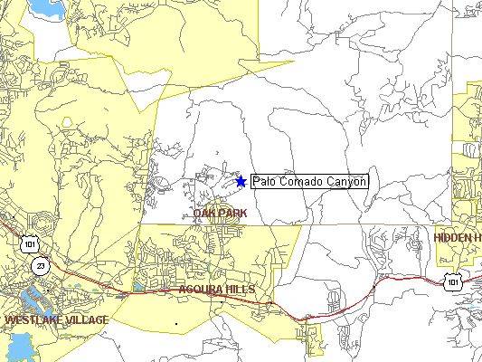
» Trails:
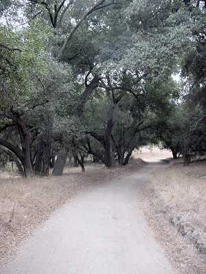
Palo Comado Canyon
Highlights:
Meadows, oak groves,
rock outcroppings
Near: Agoura Hills, CA
Distance: 6 miles round trip
Elevation Gain: 800 ft
Hike Time: 3 hours
Difficulty: Moderate
Trail Condition:
Well maintained trail
HikeType: Out and Back
------------------------------------------
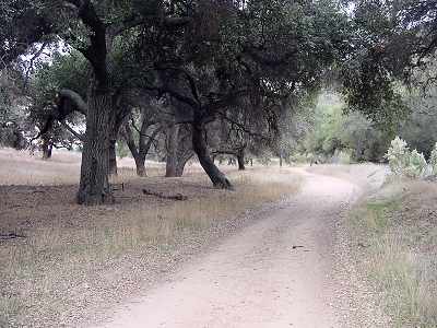
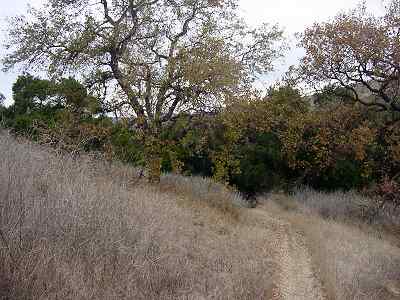
Summary: This is a pleasant relatively easy
hike through rolling grasslands and oak groves.
The first section of trail had an amazing
number of birds including scrub jays, sparrows,
mocking birds, and others I could not identify.
I found it amusing that many of the oak trees
had very small numbers on them, as if they were
addresses for the squirrels living in the trees.
The last mile or so of the hike is less pretty,
but has some interesting rock formations.
------------------------------------------
Trailhead: From Highway 101/Ventura Freeway,
exit on Kanan Road. Head north 2.2 miles to
Sunnycrest Drive and turn right.
Continue 0.8 miles to the "Public Open Space"
sign on the right. Park along the curb.
|
|
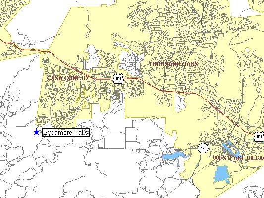
Sycamore Canyon Falls
Highlights:
Views of Boney Mountain, waterfall,
deep canyon walls
Near: Newbury Park, CA
Distance: 5 miles round trip
Elevation Gain: 700 ft
Hike Time: 2.5 hours
Difficulty: Easy
Trail Condition: OK,
but a few difficult spots
HikeType: Loop

------------------------------------------
Summary: This hike includes breathtaking
views of Old Boney Mountain as you leave
Satwiwa cultural center area and a pleasant
hike down into the steep Sycamore Canyon.
The waterfall at the hikes half way point
is this highlight. The waterfall is almost
100 foot high and consists of a number of
cascades that tumble over shear rock when
water flow is
rolex replica
 high enough. This is a rather
spectacular and secluded area. There is
a big flat topped boulder that you can
sit on to have lunch and watch the waterfall.
Watch out for the poison oak near
the waterfall as the area is covered with it!

The path shown on topo forms a loop that
goes down Boney trail, then doubles back
through sycamore canyon to hook up with
the main fire road for replica watches
 a return to the parking area.
------------------------------------------
Trailhead: From Highway 101/Ventura Freeway
in Newbury Park, exit on Wendy Drive.
Drive 2.5 miles south to Lynn Road
and turn right. Continue a mile or so,
then just past Reino road turn left
into Rancho Sierra Vista/Satwiwa Park
on the left side of the road.
|
|
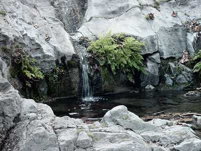
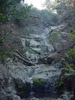
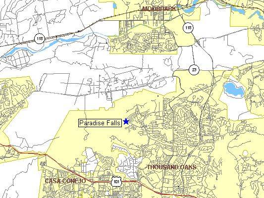
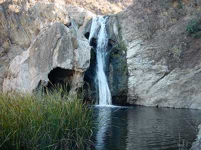
Paradise Falls - Wildwood Park
Highlights:
70 foot waterfall, shady creek side
trail, rolling hills
Near: Thousand Oaks, CA
Distance: 3 miles round trip
Elevation Gain: 400 ft
Hike Time: 1.5 hours
Difficulty: Moderate
Trail Condition: Well maintained trail
HikeType: Loop

------------------------------------------
Summary: The first part of the trail follows
Moonridge trail looking down upon Indian Creek.
Trail then drops down steeply into an area if
volcanic rock with a spectacular 70 foot
waterfall plunging into a large pool.
The return leg of
breitling replica the loop is an easy
meandering trail along the banks of
Indian creek, with a number of lovely
picnic spots along the way. I promise that you
will be surprised that there is such a nice
setting amongst the suburban sprawl.
------------------------------------------
Trailhead: From the Moorpark Freeway (23),
exit on Avenida de Los Arboles and go west
(a right turn if you are coming from Moorpark).
Follow de Los Arboles until it ends at
Big Sky Drive. Make a U-turn and the park
entrance is on the right side of the road.
|
|
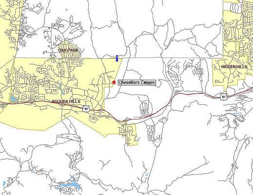
Cheeseboro Canyon
Highlights:
Lovely hike through rolling
grasslands, dotted with oak
and sycamore trees
Near: Agoura Hills, CA
Distance: 8.5 miles round trip
Elevation Gain: 800 ft
Hike Time: 4 hours
Difficulty: Moderate
Trail Condition: Well maintained trail
HikeType: Out and Back

------------------------------------------
Summary: Cheeseboro Canyon is very popular
with both hikers and bikers. It traverses
rolling grasslands covered with beautiful
oak and sycamore trees. It's a relatively
easy hike, with modest elevation gains,
and a good shady fire road to walk on
most of the way.
------------------------------------------
Trailhead: From Highway 101/Ventura Freeway
in Agoura Hills, exit on Chesebro Road.
Continue one block straight ahead, past
the stop sign, to Palo Comado Canyon Road
and turn left. Drive 0.3 miles to
Chesebro Road and turn right.
Continue 0.7 miles to Cheeseboro Canyon Rd
and turn right. The trailhead parking
lot is 0.2 miles ahead.
|
|
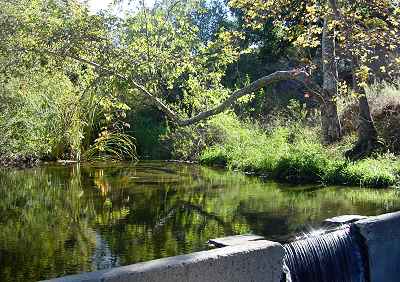
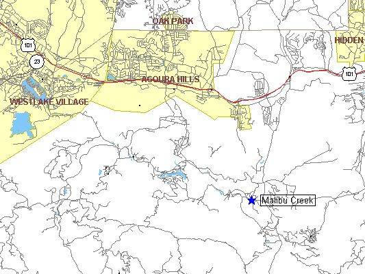
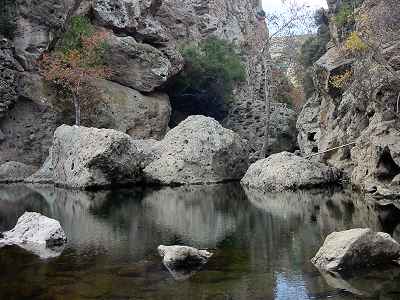
Malibu Creek - Rock Pool, Century Lake
-----------------------------------------
Highlights:
Volcanic walls, reflecting pools,
picturesque lake, and an easy hike
Near: Malibu, CA
Distance: 3.5 miles round trip
Elevation Gain: 250 ft
Hike Time: 2 hours
Difficulty: Easy
Trail Condition: Well maintained trail
HikeType: Out and Back
------------------------------------------
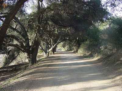
Summary: Lovely walk down oak shaded lane,
a stunning rock pool with vertical
walls of volcanic rock, and a picturesque
lake pretty enough for a calendar.
An easy hike with lots of variety.
At the Rock Pool, watch rock climbers attempt
to scale the Planet of the Apes wall, were the
movie of the same names was filmed.
When you reach Century lake, make sure to take
the path down to the lake, its a
truly spectacular place to stop for a picnic.
Those with more energy can continue
on several miles past Century lake to the
site of the old M.A.S.H television series.
-------------------------------------------
Trailhead: From Highway 101/Ventura Freeway,
take Las Virgines Road in Agora
towards the beach. Just after crossing
Mulhulland Road, you will see the
Malibu Creek State Park entrance on your right.
Park in the second parking lot.
|
|
Oakbrook Chumash Interpretive Center in Westlake:
Take the 101 freeway; off at Westlake Blvd, drive north 3 miles. Turn right on Lang Ranch Parkway. Drive 1/2 mile and enter thru iron gates on the right.
If you have any problems, questions or suggestion, E-MAIL us at any time.
|
